SOUTHERN UPLANDS


Please read Understanding catalogue records for help interpreting this information and Using footage for more information about accessing this film.
Title: SOUTHERN UPLANDS
Reference number: 0630
Date: 1937
Director: d. John C Elder
Production company: GB Instructional
Sound: sound
Original format: 35mm
Colour: bw
Fiction: non-fiction
Running time: 9.00 mins
Description:
Introduction to the Southern Uplands of Scotland with footage of sheep farming, agriculture, fishing and textiles.
For review of film see Scottish Educational Film Review Volume 1, Review No. 96. Teaching notes.
You can view this film on bfi player at http://player.bfi.org.uk/film/watch-southern-uplands-1937/ [last accessed 25/5/2016]
Credits:
ph. J Blake Dalrymple.
The GBI Geography of Scotland
Made in collaboration with a panel of Scottish teachers
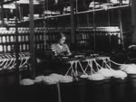
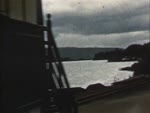
Shotlist: Credits (.25); The area of the Southern Uplands is outlined on a map of Scotland and the rivers Nith, Annan, Tweed, Teviot and Gala are marked along with main sheep farming areas (1.05) General views of sheep country in the Southern Uplands, including scenes with sheep, sheepdogs and a shepherd (2.06); A sheep is sheared by hand, using hand-clippers, and fleece is tied (3.03); More general shots of sheep in fields (3.36); On the map the natural regions of the Southern Uplands are marked the Merse of Berwick, Dales and Solway Plain (3.56); Shot in large field of wheat? - crop is cut by horse-drawn harvester which loosely ties bundles of wheat together and these are stood up to dry (4.45); Shot of beef and dairy cattle in the fields and of dairy cattle walking through farmyard (5.49); Main textile towns are marked on the map. Dumfries, Langholm. Hawick, Jedburgh, Melrose, Selkirk, Peebles, Galashiels and Kelso (6.09); Pan round unidentified town (6.21); Shot of the "Scotch Tweeds Retail" building (6.36); More general views of countryside showing sheep and cows in field (6.47); Shot of three men catching fish in river by means of a net which is pulled round in a wide semi-circle against the bank by two men in a rowing boat, then all three pull in the net and the catch (8.20); Shots of ruined castle, possibly Neidpath Castle (8.50) Shot of roadsign giving directions to main town in the area. (8.56); Shots of Melrose Abbey (9.21); ecs (9.26)